épuisé

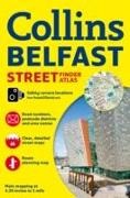
Belfast Atlas - Streetfinder

Anglais · Livre Broché

Description

En savoir plus

The area covered by the mapping extends from Ladybrook in the west, to Holywood in the east and from Belfast Castle in the north to Newtownbreda in the south. The atlas features: - Route planning road map of the area around Belfast. - Colour classified roads and streets, area names and postcode districts. - Location of important buildings and places of interest, car parks and railway stations. - Information about Belfast, such as places of interest, shopping areas, parks and gardens and getting around. - Location of safety cameras. With its large area of coverage of Belfast and high level of detail this atlas is ideal for businesses, residents and visitors.

Détails du produit

Auteurs Collins Maps, Collins UK
Edition Collins Reference
 
Langues Anglais
Format d'édition Livre Broché
Sortie 10.04.2014
 
EAN 9780007493784
ISBN 978-0-00-749378-4
Dimensions 143 mm x 217 mm x 4 mm
Thèmes Maps and Atlas
Maps and Atlas
Catégorie Voyage > Cartes, plans de ville, atlas

Commentaires des clients

Aucune analyse n'a été rédigée sur cet article pour le moment. Sois le premier à donner ton avis et aide les autres utilisateurs à prendre leur décision d'achat.

Écris un commentaire

Super ou nul ? Donne ton propre avis.

Pour les messages à CeDe.ch, veuillez utiliser le formulaire de contact.

Il faut impérativement remplir les champs de saisie marqués d'une *.

En soumettant ce formulaire, tu acceptes notre déclaration de protection des données.