Ulteriori informazioni
Cartes et vues historiques de Vienne
Vingt-quatre cartes et vues historiques de Vienne - du XVIe
siècle à nos jours - à encadrer de format standard
Cette fascinante et superbe collection comporte, entre autres, une vue circulaire extraordinaire et fidèle de Vienne à l'époque du siège des Turcs, une veduta avec les plus importants édifices de la ville, ainsi que d'impressionnantes vues des emblèmes de Vienne, parmi lesquels le château de Schönbrunn, la cathédrale Saint-Étienne, l'église Saint-Charles-Borromée et l'opéra national. Des informations détaillées fournissent des données et des faits historiques importants, ainsi que le contexte des cartes et des tableaux. L'excellent procédé technique de reproduction rend cette collection saisissante par ses couleurs brillantes et ses détails aux contours précis.
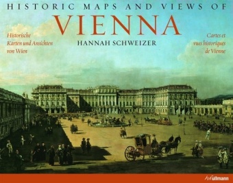
Historic maps and views of Vienna
Twenty-four historical maps and views of Vienna - from the 16th century to the present day - presented in standard picture frame size
This fascinating and beautiful collection includes a delightful panoramic view of Vienna at the time of the Turkish siege, accurate in every detail, a cityscape representation with the city's most important buildings, as well as impressive historical views of Viennese landmarks such as Schönbrunn Palace, St. Stephen's Cathedral, the Church of St. Charles, and the Vienna State Opera. Detailed explanatory texts provide historically significant dates and facts as well as background information on the included maps and pictures. The exceptional print quality of the reproductions makes this collection so compelling because it allows for brilliant colors and clear details.
Historische karten und ansichten von Wien
Vierundzwanzig historische Karten und Ansichten von Wien - vom 16. Jahrhundert bis heute - zum Einrahmen in handelsüblichen Bilderrahmen
Diese faszinierende und wunderschöne Sammlung enthält unter anderem eine bezaubernde detailgetreue Rundansicht Wiens zur Zeit der Türkenbelagerung, eine Vedute mit den wichtigsten Gebäuden der Stadt sowie beeindruckende historische Ansichten von Wiener Wahrzeichen, darunter das Schloss Schönbrunn, der Stephansdom, die Karlskirche und die Staatsoper. Ausführliche Erklärungstexte liefern historisch wichtige Daten und Fakten sowie Hintergründe zu den Karten und Bildern. Die drucktechnisch vorzügliche Wiedergabe dieser Sammlung besticht durch brillante Farben und klare Details.